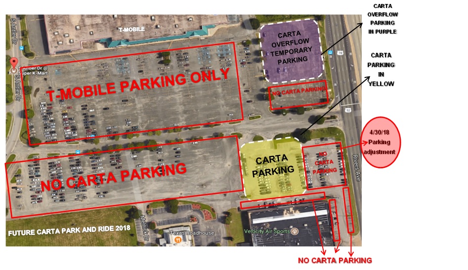
Starting on Monday, April 30th we will no longer be able to park in the front of our current parking area near Rivers Ave. and we will need more cars to park in the overflow area (purple area). It is important that we begin this process immediately to ensure that Velocity has ample space as the end of the school year draws near and we move into their busier season.
The specific area includes the first 3-5 rows of the current CARTA area near Rivers Ave. Please refer to the map below to see the exact area.
We will also have tape or rope and signs designating where to park and where not to park. Please pay attention to signage in the coming weeks and DO NOT AT ANY TIME park in any spaces around the Velocity building or in the T-Mobile areas we have been communicating to you shown in red on the map below; please only park in the yellow or purple areas shown on the map below. Both businesses have informed us that they will tow vehicles that are parked outside of the designated areas, so please review the map carefully and pay attention to signage in the parking lot.
Currently we have plenty of space in the overflow (purple area), however if we start to run low on spaces we have additional overflow parking available and staff will provide that information when and if this issues occurs. Staff will continue to be on site periodically each week to monitor and assist with the parking situation.
Recently portions of our land have been cleared in preparation for the next step in turning the space into our future home; you should begin to see more activity in the coming weeks.
We can also anticipate additional adjustments to the current parking area before our area is completed late this summer.
This process has taken longer and is more complicated than anyone anticipated. We apologize for this ever-changing situation and we thank you for your continued patience as we continue to try to work with all our neighbors until our area is ready for use.
Please know we are trying our best not to cause disruptions to your daily routine while at the same time continuing to provide a place for everyone to park. Please let us know if you have any questions or concerns.
*May 2018 correction-In the original image, one row was left in the yellow area that should have been in the no parking area.