fbpx

Charleston Area Regional Transportation Authority

CARTA connects Charleston-area transit riders to work, school, healthcare, tourist attractions, the airport and more.

Plan Your Trip

Rt. 31 Detour due to water main break – Effective 02/12/24

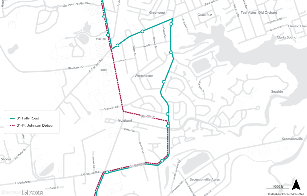
Due to a water main repair near Fort Johnson Rd., Rt. 31 will be detouring until further notice.  See map for the detour.  Several stops will be missed along Secessionville Rd. and Fort Johnson Rd. including:

680 Folly Rd / Fort Johnson
658 Fort Johnson Rd / Jeffords St
531 Fort Johnson Rd / Freer St
659 Fort Johnson Rd / Secessionville Rd
657 Secessionville Rd / Sineca Pl
656 Secessionville Rd / Thomas Johnson Park
655 Secessionville Rd / Westmoreland Ave


Call 843-724-7420 with any questions.

Plan Your Trip
Transit App

Download “Transit” and travel like a true Charlestonian.

Available in the App Store and on Google Play, “Transit” offers numerous features to help you easily navigate around Charleston.

Bus Route: See vehicle locations in real time, find nearby stops, and receive stop announcements.

Service Alerts: Keep on top of schedule changes, stop relocations and other unexpected surprises.

Favorites: Always take the same bus? Move it to the top of the list by adding it to your favorites.

Timetables: View the full schedule for a route and set alarms to remind you to leave.

Countdowns: Get real-time predictions based on data from the transit agency.

“Go”: Get step-by-step transit directions and notifications about when to leave for your trip and when to get off the bus.

Plan a trip!: Compare trips side by side with your preferred transport modes selected.

View Transit 101

Download TransitApp from Google Play Store
Download TransitApp from Apple Store
TransitApp