![]()
A Berkeley-Charleston-Dorchester Council of Governments Program
CONSTRUCTION TO LIMIT HOP LOT ACCESS THROUGH EARLY JUNE
RIDERS ASKED USE ALTERNATE BUS STOPS
NORTH CHARLESTON (April 1, 2020) – Due to construction impacts, access to the HOP park-and-ride lot will be limited beginning Wednesday, April 8, with impacts projected to last through early June.
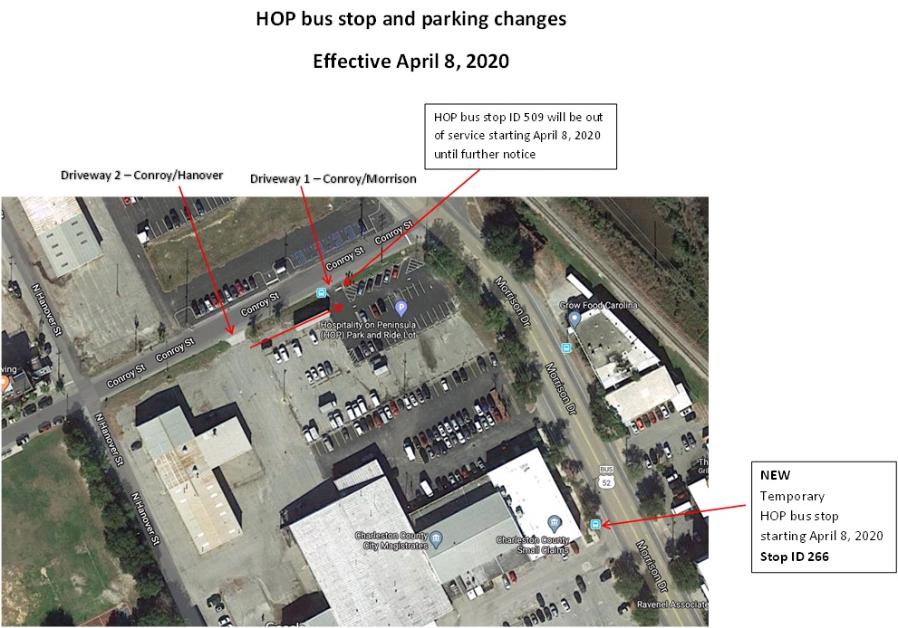
Motorists will still be able to access the lot via one of two driveways located on Conroy Street. The accessible driveway will change as the project progresses. Conroy Street will temporarily not be accessible via Morrison Drive.
The HOP bus stop will shift to Morrison Drive near the Charleston County Magistrates Court at 995 Morrison Drive (Stop 266) for the duration of the project. Riders who normally use Stop 509 should use the new, temporary HOP stop. Pedestrians should walk through the lot to reach the temporary stop.
Beginning Wednesday, April 8:
- The Primary HOP stop will shift from Conroy Street (Stop 509) to Morrison Drive at the Charleston County Magistrates Court building (Stop 266). Stop is located adjacent to the current park-and-ride lot.
- Bus Stop 516 located at 930 NoMo will not be served during the project. Riders can use stop 266 in the interim.
- The HOP shuttle may be detoured while on route, but detours will not affect any stops.
- Passengers will need to access the HOP lot via Driveway 1 on Conroy Street (closest to Hanover Street) via Hanover Street. Conroy Street will not be accessible via Morrison Drive and Driveway 2 (closest to Morrison Drive) will be closed.
As construction continues through June, passengers can expect additional changes and possible delays in the area. Staff will provide updates via transit app, driver announcements and area signage.
ABOUT CARTA
The Charleston Area Regional Transportation Authority is a public transportation system dedicated to providing affordable transit in the Charleston community through local fixed routes, on-demand paratransit service and express commuter routes. For the latest on CARTA, visit ridecarta.com, like us on Facebook or follow on Twitter at @RideCARTA. All customers are encouraged to plan rides and track buses with the CARTA-endorsed Transit app.
###
MEDIA CONTACT:
Marquel Coaxum, Account Supervisor
Rawle Murdy
mcoaxum@rawlemurdy.com
(843) 475-4208
Daniel Brock, Regional Strategist
BCDCOG
danielb@bcdcog.com
(919) 820-2612